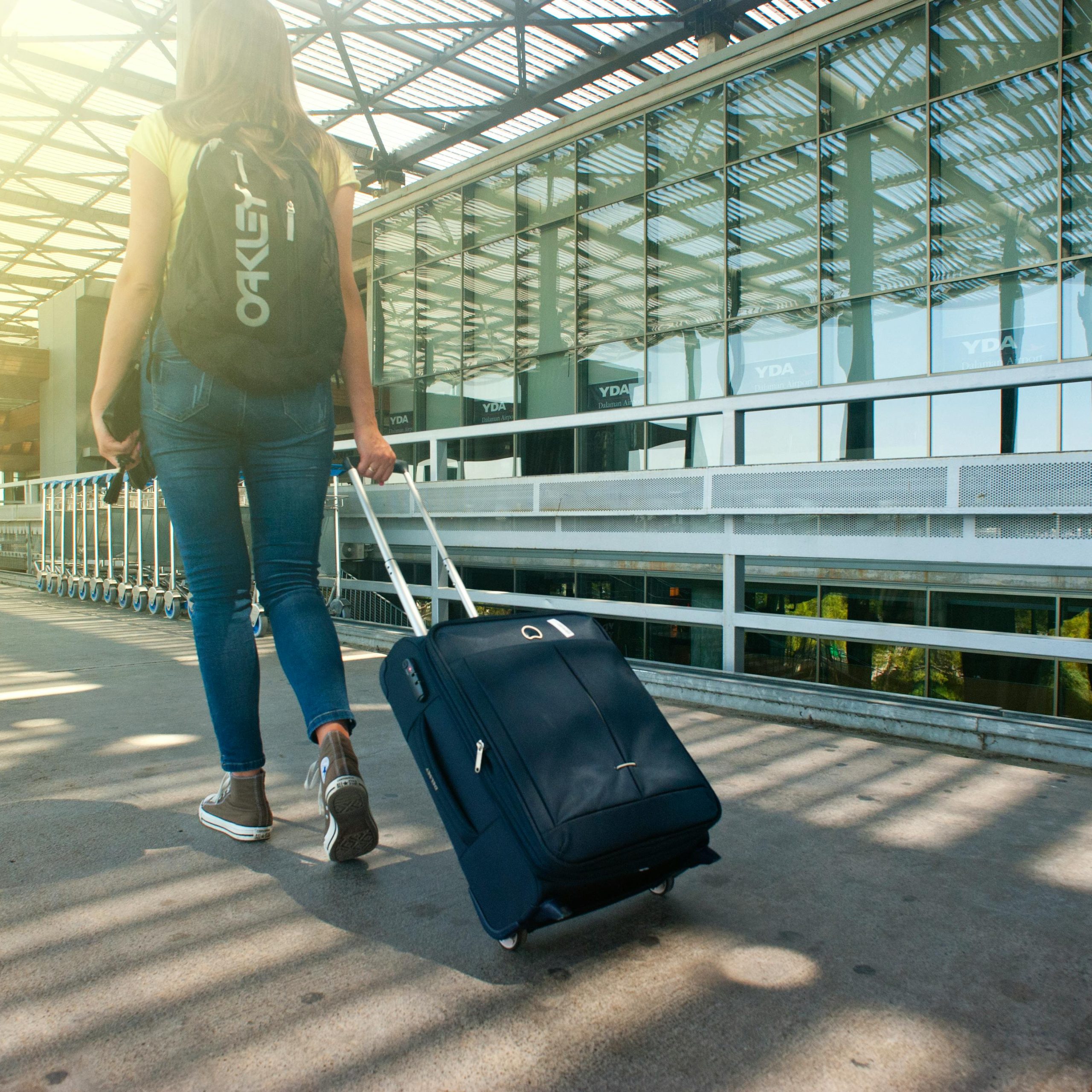
Planning Your Trip to Palestine: Are you preparing for an unforgettable journey to Palestine? From navigating visa requirements to finding reliable transportation and choosing accommodations, careful planning will ensure a smooth and enriching travel experience.
This guide provides essential tips to help you get ready, including advice on downloading maps, understanding SIM card usage, and navigating airports and checkpoints. Whether you’re a first-time visitor or a seasoned traveler, these insights will help you plan a safe and memorable trip to Hebron and beyond.
Read on to discover all you need to know before embarking on your Palestinian adventure!
Table of Contents
Planning Your Trip to Palestine: Before You Leave to Palestine
1. Online for visa and travel information
- Each country should have a website that tells you how to enter Palestine.
- Currently, most Americans and Europeans receive a three-month tourist visa upon arrival to Israel and, once clearing customs, are granted access to both Israel and Palestine.
- Please verify this information with your country’s travel advisory website or your nearest Israeli Embassy or Consulate.
- Ensure you submit the ETA: As of January 1st, 2025, Israel requires an Electronic Travel Authorization to be submitted before you travel to the country. The check-in desk at the airport will request it. The form will ask you for your personal details, travel date, how long you intend to stay, and whether you have been denied entry to Israel. Make sure to fill it out and submit it before booking your flight if it is not approved. If approved, the ETA is valid for 2 years, and you may travel for up to 90 days at a time during that period.
2. Personal Phone Usage
- Internet access in the region, beyond free Wi-Fi hotspots, is unlikely.
- Please check your network carrier rates for international roaming before departure, as it will likely be expensive.
3. Using a separate SIM card
- Only purchase from Palestinian providers Jawwal and Wataniya, as they are the only carriers to provide signal up to 3G in Hebron.
- Israeli SIM cards do not work in Hebron.
- Both Jawwal and Wataniya have roaming agreements with Israeli carriers so that you will have a 3G signal on trips into Israeli territory.
4. Maps
- Download a navigation app to your phone, such as maps.me.
5. Arriving late/evening/at night
- If your flight arrives late in Israel, please stay a night in Jerusalem or Tel Aviv before traveling to the Excellence Center in Hebron the following day.
- The Excellence Center is open 8 am to 8 pm, Saturday to Thursday, and it is more convenient to staff to liaise with visitors during business hours.
- Please visit the Navigating Jerusalem section for further travel information.


Choosing Your Flight to Palestine
Airport Destination to Palestine
1. Ben Gurion Airport (TLV) in Tel Aviv, Israel
- Recommended the airport for easier transportation to Hebron, Palestine
- Avoid flights that arrive on, or just before, the Jewish Sabbath (Friday sunset to Saturday sunset), as public transportation will not be available, and there will be fewer taxi options.
- Please contact the Excellence Center if your arrival date is in that period for help securing a taxi pick-up.
2. Queen Alia Airport (AMM) in Amman, Jordan
- However, there might be difficulties in crossing the Palestinian-Jordanian border at the Allenby-King Hussein Bridge.
- Long delays might also require a visa and accommodation in Jordan at an additional cost.
- Crossing at the Aqaba-Eilat border is also possible but requires the purchase of a bus ticket from Eilat to Jerusalem before continuing to Hebron.
- Please call the Excellence Center if you plan on traveling through Jordan; they will help you plan your trip.
Arriving in Israel
Navigating Ben Gurion Airport
1. Israeli Customs
- Explain to the customs officer that you plan on staying in the Palestinian (H1) area of Hebron.
- It is rare for them to take your passport, however, if they do it may lead to an interview.
- Be polite, diplomatic, and honest; they will return your passport and allow entry.
2. Food at Tel Aviv Airport
- The Tel Aviv airport’s food court and store options are limited.
- Still, you will find some useful amenities.
3. Travel Money
- If you have not bought travel money before travel, head to the airport’s currency exchange.
- Shekels (ILS) are accepted in Israel and Palestine and will get you out of the airport and to your destination. Also, if you are having trouble finding ground transportation, there is an information desk that will assist you.
4. Ground Transportation
- The airport’s information desk can advise where to access public transport to take you out from the airport.
- Signs will also provide directions to bus stops and stands for sheruts/services or taxis.
5. Buses:
- The bus is the cheapest travel method and can be used for every part of your trip.
- Sheruts (Hebrew)/Services (Arabic):
- These are shared taxis, recognizable as orange minivans or white mini-buses.
- They have a set destination, but the departure time depends on when the vehicle reaches full capacity.
- If you are the sole rider in the service as the driver is ready to leave, they might charge you the taxi rate, but you can insist on paying only the recommended rate. The driver won’t accept your offer, and you can leave for a different service.
- Leave yourself a good time to reach your destination using this service.
- It’s easier to refuse an expensive ride if you know you can wait for a cheaper one.
6. Taxis
- Private taxis, recognizable as yellow cars.
- The most expensive option.
- As a foreigner, drivers might convince you to travel with them, but a sherut/service or bus is often the more economical option.
Getting to Hebron, Palestine
Israeli Checkpoints
- From Ben Gurion Airport
- The airport is located in Lod, close to Tel Aviv, so it’s quicker and more efficient to take a route directly to Jerusalem.
- Afikim bus 485:
- The bus stop is located on the second floor of the terminal.
- Costs 16 ILS per ticket
- It will take you to the “Afikim Main Stop,” near the Central Bus Station, but not at the Central Bus Station.
- Ask the bus driver for help or look up the stop online to ensure you get off at the correct stop. On Google Maps, it is called “ICC / Shazar”.
- Takes about one hour, and runs every hour at the top of the hour, 24 hours a day EXCEPT between 2 pm on Fridays to 7 pm on Saturdays.
- Once you’ve arrived, you can walk, take a train, or take a taxi to the hotel or hostel that you reserved prior.
- More information can be found on Afikim‘s website.
- “Nesher” Service Taxis to Jerusalem:
- Select a route to Central Jerusalem or the Jerusalem Central Bus Station.
- Costs 41 ILS.
- More information can be found here.
- Afikim bus 485:
2. Jerusalem bus stations
- A blue light rail line connects the Central Bus Station to the Arab Bus Station. Staying near that portion of the light rail line will keep you close to either bus station and will provide you with a convenient means of transport to and from both.
- Central Bus Station
- Connects to all points in Israel, including the airport
- Bus:
- The cheapest option is to take either bus 381 or 383 from the Central Bus Station to the Israeli side of Hebron.
- Board either of these buses on the third floor of the station at gate 6.
- Buy your ticket when you board the bus. It costs 8.1 ILS (8 Shekels and 10 Agorot).
- Take the bus to the last stop on the line, Bet Romano, which is marked on the map to the left with a pin labeled “Bet Romano”
- Takes about one hour.
- Following the badly drawn blue line on the map upon arrival until you reach the stadium. It takes no more than 30 minutes to walk.
- Ignore your navigation app if it says you can’t cross the checkpoint, as it will send you 3 hours out of your way to reach your destination.
- Central Bus Station
3. Arab Bus Station
- Connects to all points in Palestine.
- Service (shared taxi):
- It’s the most convenient option.
- Services are usually parked on Ha-Nevi’im Street or in the corner of the parking lot.
- Drivers can be heard shouting: “Al Khalil! Al Khalil! (Arabic for Hebron).
- The cost is about 25-35 ILS, and the trip should take about 50 minutes.
- The destination is the al-Hussein bin Ali School (Madrasat al Hussein Ben Ali Althanawieh)
4. Bus:
- It’s a cheaper option but more complicated.
- Bus number 231 to Bethlehem gets you around the Israeli checkpoint. Bus 234 to Bethlehem drops you off right outside the Israeli checkpoint.
- At times, like Fridays during Ramadan, the bus stop caters exclusively to bus 234.
- People at the bus drop-off can guide you to the proper bus.
- Take a bus to Bethlehem, then take a service to Hebron.
- It will cost 7 ILS for the bus to Bethlehem and 9 ILS for the service to Hebron.
5. Taxi in Hebron:
- You can find a taxi shortly after crossing the checkpoint.
- Tell the driver you want to go to the Al Hussein Bin Ali School (Madrasat al Hussein Ben Ali Althanawieh).
- It should cost 3 ILS.
- From there, the section on Navigating Hebron will get you to the Excellence Center.
Navigating Bethlehem
- If you take bus 234, you’ll find yourself at the bus stop at the traffic circle at the top of this map.
- Once you go through the Israeli checkpoint, you’ll be at the place where the blue walking path on the map begins.
- Usually, you’ll be able to find a service right after you cross the checkpoint.
- If you don’t find a service, follow the blue walking path on the map until you get to Bab-Azqaq. You’ll notice that you are being directed away from the grey walking path. That’s because that path is cut off by the separation barrier.
- If you take bus 231, you’ll be right near Bab-Azqaq. It’s not quite as close to the intersection as the bus stop on the map indicates, but it’s only about a block away.
- Bab-Azqaq is the intersection between Hebron Road and Derech Beit Jala. The services gather at the SW corner of the intersection. Whether you get service near the checkpoint or at Bab-Azqaq, you will hear drivers shouting: “Al Khalil! Al Khalil! (Arabic for Hebron).
- The cost for one of these will be 9 ILS, and the trip should take about 40 minutes. Before you board, tell the driver you want to go to the Hussein bin Ali School (Madrasat al Hussein Ben Ali Althanawieh).
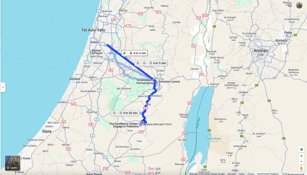
Navigating Hebron/Getting to the Excellence Center
- Mapping programs don’t have the correct information for our locations so please refer to the map below as a guide for how to get to our Excellence Center locations.
- If you have given your destination as Alhussain Bin Ali School, you will arrive at the red pin on Ein Sarah Street.
Our Location:
- Go south on Ein Sarah Street until you pass the stadium.
- Turn left. Pass the stadium again and the mosque just behind it.
- Turn left onto the alley just after the mosque.
- This alley stretches between the blue dot and the stadium on the map.
- Go to the second set of doors.
Any questions?
Should you have any questions, please do not hesitate to contact us:
- Via email: at Rafat@excellencenter.org.
- Via Whatsapp:+972 599 479 880
Find Us Online
Study in Palestine: https://studyinpalestine.org/
Engage in Palestine: https://ecpalestine.org/
Volunteer in Palestine: https://volunteerinpalestine.org/
Facebook page: https://www.facebook.com/ExcellenceCenter
Watch us on Youtube: https://www.youtube.com/channel/UCsQSLdFZWZcBm6Uj0XMYuKg
Instagram: https://www.instagram.com/excellence.center/